Why are dynamic baselines necessary for high-quality reforestation credits?
Reforestation is a critical carbon removal strategy that uses nature to address climate change. But to realize nature’s potential, we must take significant steps to cut net deforestation to zero, while committing to reforesting an area about 10 times the size of Texas 1.
Achieving reforestation on such a massive scale means we need a big boost in carbon finance for landowners who are ready to lead these efforts. This, in turn, can only be achieved by building trust in the carbon credits that come from reforestation projects.
The credibility of carbon crediting comes down to whether we can accurately and transparently quantify the climate impact of reforestation projects.
Sometimes forests naturally regrow after land use changes, such as when farmland is abandoned. This background reforestation can often be small, but not necessarily negligible. Any reforestation project should only be credited for its carbon uptake above and beyond the background rate within the surrounding region.
Want to dive deeper into Pachama’s tech?
See what core technology Pachama is developing, how we evaluate project quality, and why we’re building the next generation of nature-based projects.
How can we quantify background forest regrowth?
Let’s dive into how we measure forest carbon gains on and around reforestation projects. This is where dynamic baselines come into play, recently adopted by Verra and the ABACUS label as performance benchmarks for afforestation, reforestation, and revegetation (ARR) projects.
A dynamic baseline for a reforestation project is conceptually the same as the dynamic baselines for avoided deforestation projects that Pachama has previously described. But instead of looking at deforestation rates in a control area, we quantify reforestation in the control area.
While the idea is straightforward, there are some technical nuances to consider, especially when it comes to measuring carbon uptake in the control area.
To explain these nuances and their commercial and policy implications, Pachama has released a Research Brief demonstrating the implementation of dynamic reforestation baselines.
Our Research Brief highlights the importance of having accurate forest height (or carbon) data for calculating dynamic baselines. It also points to the limitations of using simpler satellite data, which is readily available online, but can lead to unreliable baselines.
In this blog, we break down the main findings from our Research Brief. Whether you’re a project developer, a landowner, a credit buyer, a credit registry, or a project auditor, here’s what you need to know about dynamic reforestation baselines.
What should you know about dynamic reforestation baselines?
Site your reforestation projects in a region with little to no background reforestation.
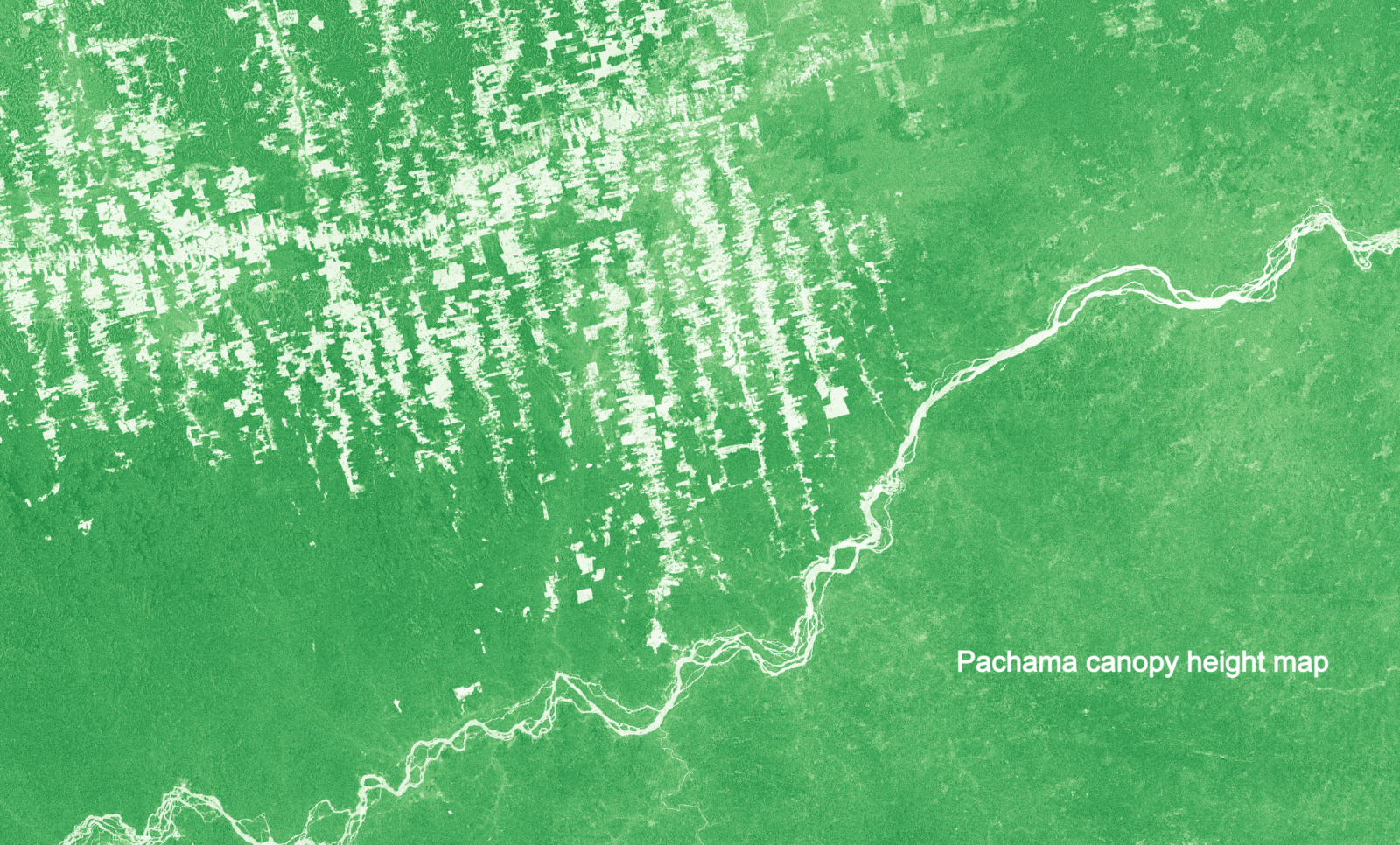
This recommendation might sound like common sense because regions with lower background regrowth will have lower baselines and higher credit issuance. However, we emphasize the importance of actually checking recent rates of forest regrowth in the surrounding region before diving into a project. We conduct this assessment for all Pachama Originals projects using our canopy height data. Plus, we’re working on a user-friendly web platform, so project developers can do the same.
This is crucial for bolstering confidence in project additionality. Market policy and infrastructure for digital measurement, reporting, and verification (DMRV) are evolving to independently validate the carbon proxies used for dynamic baselines, so that one can be confident that an estimated 15% baseline deduction, for example, (i.e., 15% carbon gain in the control area) isn’t actually 25%? Or that a carbon proxy showing zero carbon gain in the control area isn’t failing to detect a 5% gain?
But in the meantime, we can tackle this by choosing project locations where satellite data shows almost no reforestation to begin with.
If you want to issue credits 3-5 years after the project start date, use canopy height or carbon maps to compute dynamic baselines.
Under Verra’s new ARR methodology (VM0047), credits cannot be issued until satellite data shows that there’s more growth happening in your project than the control area. If your satellite data isn’t picking up on the early growth or is too noisy over the control area, you run the risk of being unable to issue credits in early project years (e.g., years 3-5).
We’ve observed this problem with some satellite-derived proxies, which can be weakly correlated with forest carbon. These simple proxies are sometimes unable to detect a difference between small saplings growing in your project and any existing vegetation in the control area.
But with Pachama’s canopy height data, we see a clear increase in canopy height after reforestation starts, while the control area stays the same. This early, but noticeable, difference in height between the project and control can often enable credit issuance within the first 3-5 years of the project.
For project developers and landowners looking to get a head start on earning credits and carbon revenue, using Pachama’s platform to compute dynamic baselines is the way to go.
If you want to avoid under-crediting, use canopy height or carbon maps to compute dynamic baselines, instead of simpler, “off-the-shelf” carbon proxies.
Reforestation projects typically start with low carbon stocks, and so do their control areas. Our Research Brief demonstrates that simple carbon proxies are often noisy over low-carbon control areas, sometimes showing changes that do not correspond to real carbon change.
We found that these proxies can produce incorrect baseline deductions as high as 20-30% when, in reality, there’s hardly been any change at all in the control area. In other words, if you rely on a simple carbon proxy, you might end up getting fewer credits than you should.
In contrast, Pachama canopy height data is more stable and doesn’t generate false height increases over control areas. In our test cases, where satellite images confirmed no new trees growing in control areas, our maps showed no change in height. This level of accuracy means a reforestation project won’t be shortchanged and can receive the actual number of credits deserved.
The market will need to adopt canopy height or carbon maps to compute dynamic baselines beyond the first 5-10 project years.
Simple carbon proxies just don’t cut it when it comes to figuring out a dynamic baseline over the life of a project. The problem is they hit their maximum value (i.e., they saturate) in the early years of reforestation.
Why do simple proxies saturate?
Well, these proxies mostly look at how dense and green leaves are. So once your project has a full canopy of trees, some proxies no longer increase, even though your trees keep growing and accumulating carbon for decades to come.
This presents a challenge because, to compute a dynamic baseline, you need the carbon proxy to track change in both the project and its control area. Pachama’s canopy height data can accurately track forest height over the full life of a reforestation project.
Next steps
Our research brief demonstrates the potential for dynamic baselines to ensure high-integrity, scalable, and transparent crediting for ARR projects. Pachama is committed to realizing this potential.
First, we’re using our canopy height data to screen for low background reforestation rates and to compute dynamic baselines for all Pachama Originals projects. Second, we’ve developed an interactive platform for landowners and project developers. It offers key services, including parcel-level eligibility analysis,a an estimated credit issuance over a project’s lifetime, and expected baselines based on regional reforestation rates. If you’re interested in getting a sneak peek, please contact us.
Last but not least, we’re working with credit registries and other technical market actors to develop the policy and DMRV infrastructure necessary for third-party validation of the carbon proxies used to compute dynamic baselines.
After all, when it comes to trusting a carbon proxy, it’s crucial to have someone else double-check it against an independent, ground truth database to ensure that the resulting baseline deductions are correct.
Ready to build your nature strategy?
Get in touch with our team of experts to learn how we can help you invest in tech-verified projects or start your own project from the ground up.
FOOTNOTES
a Our primary eligibility check is to confirm that a parcel has been non-forest for the last 10 years. This check is to prevent landowners from deforesting lands only to then claim reforestation credits.
REFERENCES
1 Griscom BW, Adams J, Ellis PW, Houghton RA, Lomax G, Miteva DA, et al. Natural climate solutions. Proc Natl Acad Sci U S A. 2017;114: 11645–11650.