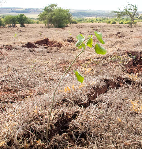
Pachama’s Tech Explained

How earth observation and artificial intelligence can drive the next generation of investments in nature

01 / PACHAMA’S CORE TECHNOLOGY

Building a
modern, scalable
carbon market

ExpandCollapse

Our core technologies

At Pachama, we’re developing three core technologies required to modernize the voluntary carbon market and create a future where high-integrity, transparent carbon credits can scale at the speed our planet demands.

  • Estimating carbon

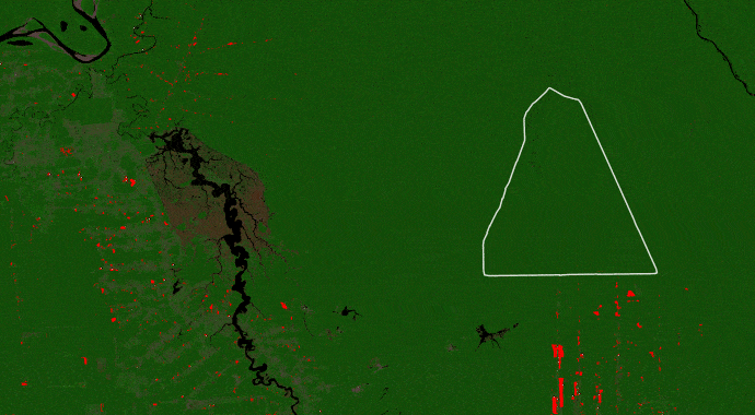
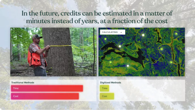
    Status Quo: Field crews measure individual trees by hand to inventory carbon stocks over a small sample of a project’s area. This process costs tens to hundreds of thousands of dollars and can take months—or even years.

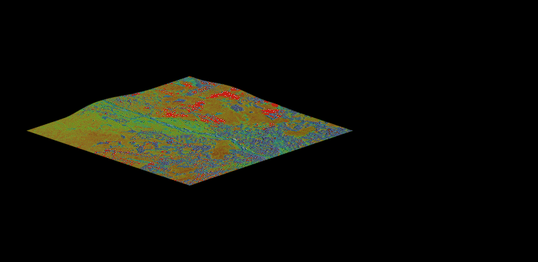
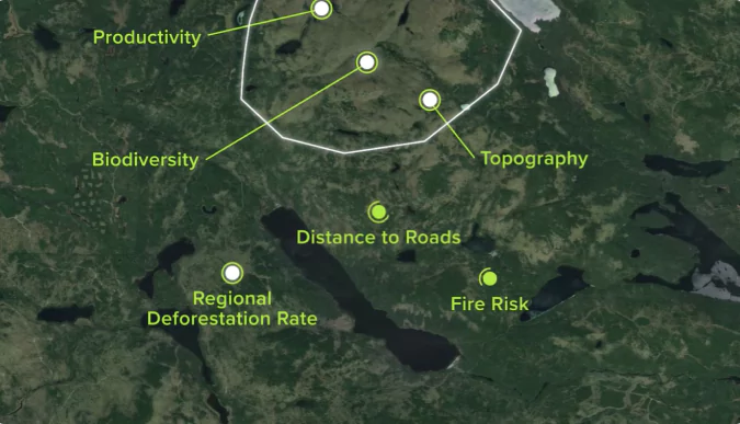
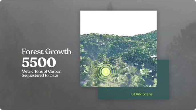
    Pachama’s Approach: We are building machine-learning models that integrate satellite data, field plots, and 3D airborne lidar imaging to map forest carbon over entire regions, and eventually, anywhere in the world. This satellite-based carbon mapping unlocks a more scalable, cost-efficient future for crediting.

    See how satellite-based carbon mapping can help scale forest carbon markets

  • Monitoring forest cover change

    Status Quo: Most registries require that projects are monitored only every 3 to 7 years. Years could pass without information of a forest fire or illegal deforestation.

    Pachama’s Approach: We use high-resolution satellite imagery and cloud-penetrating radar to track losses and gains in forest areas over time, unlocking continuous visibility across an entire forest.

    Watch a product demo

    Monitoring forest cover change
  • Assessing the baseline

    Status Quo: In forest carbon markets, a baseline is a business-as-usual scenario used to estimate expected emissions without the incentive of carbon financing. Today, credit issuance relies on historical data and a complex set of subjective factors to set baselines.

    Pachama’s Approach: Using machine learning models, we match each satellite pixel in a project to a ‘control’ pixel outside the project with similar attributes. We then use satellite data to observe forest loss in the control pixels compared to the pixels in the project area.

    See how a tech-driven approach to baselines can transform carbon crediting

PUTTING IT ALL TOGETHER

Digitizing the
carbon market

Digitizing the <br> carbon market

Since our founding in 2018, we’ve sought to lead the way in Digital Measurement, Reporting, and Verification (DMRV). Our goal is to create a registry-integrated system that provides a modern, intuitive experience for both project developers and buyers through a transparent, simplified crediting process.

COLLAPSE
02 / PACHAMA VERIFIED PROJECTS

Finding the world’s highest-quality forest projects

ExpandCollapse
Invest with Confidence

Project evaluation

Pachama rigorously evaluates every project listed on our marketplace to ensure we’re surfacing only the highest quality projects. Our Evaluation Criteria includes a series of checks that every project must pass, as well as a number of informative insights on project quality. In each evaluation, we ensure the project is:

01
Additional

Emissions reductions would not have occurred without the the incentive of carbon credits.

02
Conservative

Emissions reductions are robustly quantified and each credit represents at least one metric ton of carbon.

03
Durable

The project delivers a long-lasting climate impact ensured by continuous monitoring and reporting

04
Beyond Carbon

The project causes no net harm and delivers biodiversity and community benefits

Data at your finger tips

Monitoring projects

Access data at your fingertips with Pachama’s Portal. Unlock interactive data visualizations and see the impact of each of your projects, including:

Ongoing project updates

Climate impact

Climate impact
CLIMATE
Heartbreaking deforestation at the project’s doorstep

On a recent project visit, Pachama captured drone footage and images of the Manoa forest and...

Community engagement

Community engagement
COMMUNITY
Experiencing the project's community impact firsthand

A Pachama representative visited Manoa and experienced the incredible work the project is doing on the ground. He said, "I could see...

Biodiversity tracking

Biodiversity tracking
BIODIVERSITY
Jaguar spotted at a watering hole

Camera trap footage of a jaguar stopping for a drink the Saleiro, salt lick, where many animals go to drink or to lick the stones...

Carbon Monitoring

Regional deforestation risk

Regional deforestation risk

Annual climate benefit

Annual climate benefit

Interactive forest loss

Interactive forest loss
COLLAPSE
03 / PACHAMA ORIGINALS PROJECTS

Building the next generation of nature‑based projects

ExpandCollapse

Derisked investments in nature

With tech at the forefront, Pachama enhances project design, tracks project performance, and brings unprecedented accuracy and efficiency to carbon credit issuance. By surfacing data in one intuitive portal, companies get complete transparency into the ongoing health and impact of their project.

Find the best projects

Find the best projects

Pachama analyzes regional characteristics to find the ideal project areas that will ensure your investment delivers the maximum impact on the climate, communities, and local wildlife.

Track and share progress over time

Track and share progress over time

Pachama’s suite of in-the-sky and on-the-ground technology, paired with machine learning, enables you to monitor progress and identify potential risks sooner.

Automate credit calculations

Automate credit calculations

Pachama’s digital measurement technologies will take the manual processes of estimating carbon from months to days, bringing all of the rigor of traditional methods at a fraction of the cost.

See Pachama Originals in action

Developed in collaboration with Delta Land Services, LLC, the Avahoula Climate Action Project seeks to reforest an area greater than 5,400 football fields in the Mississippi Alluvial Valley.

COLLAPSE
We're here to help you become nature positive!
Contact Us